Back in the 19th Century the boats used to set out from the northeast coast of Scotland in search of whales. These boats used to head up to Shetland and then strike north towards the Greenland coast in search of right whales and humpback whales.
Now-a-days there are still occasionally boats that set out from the northeast coast of Scotland in search of whales. And as in the past they head up to Shetland and then strike north towards Greenland in search of whales. There are differences. The whales being sought are mostly orca and fin and minke whales, and the searchers are armed with big lenses rather than harpoons. I’m guessing that the boats are rather more comfortable than would have been in the case in the 19th Century.
 |
| Ortelius in Svalbard |
I was lucky enough to be on the Ortelius when it left Aberdeen recently heading northwards in search of whales and hoping to be able to land on Jan Mayen island off the Greenland coast, before winding up in Svalbard.
If I’d done a bit a due diligence, I might have found out that in recent years this trip has on occasion suffered from wild sea conditions, seen very few whales and failed to be able to make landings in Jan Mayen. Sometimes all three. However when I found that this was a way to visit Jan Mayen, I didn’t do any such due diligence, I just paid my money and assumed that it would all work out right!
It’s nice that such naivety does occasionally pay off. :-)
We left Aberdeen on a calm Monday evening and headed slowly northwards, the Ortelius always heads slowly - top speed is about 10 knots. By breakfast time the next morning we could see Fair Isle ahead of us, and by 09:30 we were being zodiac’ed ashore into North Haven. It was a bit odd being 25 miles from the house on Shetland but not visiting there, it was however delightful to be back on Fair Isle, and I think I can honestly say it’s the first time I’ve arrived on Fair Isle not feeling seasick. The Ortelius may be rather smaller than the Northlink boats that ply between Aberdeen and Shetland, but it is a lot bigger (and more stable) than the Good Shepherd that carries people between Fair Isle and the Shetland mainland. On Fair Isle both the human and puffin population turned out in force to welcome us, and we got some glorious summer weather too.
 |
| Shetland Puffins |
 |
| Typical Fair Isle weather |
Having had a little taste of Shetland, we were zodiac’ed back to the Ortelius and the serious business of heading north could start. Jan Mayen was our next planned landfall some 1300 km away.
If the weather is wild this can be a pretty unforgiving area of sea - but if you get lucky it can be smooth and whales, while never easy to spot, get significantly easier to see. This is particularly true as you get further north and the whales blows get clearer as the air temperature falls. It’s difficult to not think ‘There she blows’ when you see a blume in the distance, and hearing someone excitedly shout this out loud is still one on of my highlights from the early part of the trip. One of the bonuses of the slow moving Ortelius is it’s nimbleness in turning when a whale is spotted, and we had several episodes when we were able to get really clear looks at a range of different whales species during the two days it took to get to Jan Mayen.
 |
| Northern Bottlenose Whales |
 |
| Minke Whales |
During these two days we saw big pods of long-finned pilot whales, lots of northern bottlenose whales (including a pair that dived right under the bow of the ship), fin whales and minke whales and orca too. Cold flat seas are perfect for whale spotting, but when you’re seeing whales several kilometres away it can be pretty challenging to identify them, but I’d think that is something to list under ‘good problems to have’.
As we had been heading north the expedition crew had been keeping us updated on the Jan Mayen weather. We knew that we’d had remarkably calm weather south of Jan Mayen, but Jan Mayen is (in meteorological terms, at least) a law unto itself. The big feature of Jan Mayen is a very large active volcano - Beerenberg. This volcano rises almost 2300 metres above level, is flanked by a series of glaciers and completely dominates the north end of Jan Mayen - the sheer scale of the mountain and it glacier collection make is a perfect breeding ground for catabatic winds that can make landing on the few beaches very hazardous. It is claimed that the top of Beerenberg is only clear of cloud on 3 days each year. It’s my sad duty to confirm that the day I visited wasn’t one of those days.
 |
| Jan Mayen - weather/communication station |
 |
| Kvalrossbukta, Jan Mayen |
We able to land at two sites on the island, at Batvika on the southern side and at Kvalrossbukta. on the northern side. Although both landings were completed successfully we did get a brief glimpse of how fast the weather can change, as a rogue wave successfully swamped one of the zodiacs (finally dispelling any ambiguity in what is meant by a wet landing).
After the second landing we cruised along the mouth of Engelskbukta (English Bay) hoping that we might get a glimpse of top of Beerenberg, but that is going to have to wait for another visit, before again turning north in search of the sea ice off the Greenland coast. It’s about another 1000 km from Jan Mayen to Longyearbyen in Svalbard, but we opted not to follow a direct route. Instead we continued north in search of ice before turning east to get to Svalbard.
It’s worth pointing out that this far North at this time of year there is 24 hour daylight - so we were watching for wildlife throughout the 24 hours each day. This meant that the ‘day’ would start with a tannoy message “Good morning, good morning, there are orca directly ahead of the ship”, and just as you were contemplating getting a bit of shut-eye in the evening - “We think we’ve just spotted polar bears on an ice floe directly ahead”. Both messages pretty much guaranteed to result in a frantic charge to the ships forward viewing points - and both happened on the same day.
 |
| Orca |
 |
| Bears on Ice |
As we headed further north and west we found much more sea ice - but not yet any well-defined ice edge, which is where we might have hoped to find a variety of sea mammals - as the ice became a bit more joined up we found quite a lot of hooded seals (a meal-time favourite of the polar bears) and recent polar bear tracks, but no further sightings of polar bears.
 |
| Hooded Seal heading for safety |
 |
| Bear Tracks |
At this point the calendar started to catch-up with us and we needed to head eastwards to get to our dock-date in Svalbard - and as we headed east the weather decided to give us just a little flavour of how things might have been during the rest of the voyage. An afternoon and evening of rolling through the waves was a reminder that the seas in this part of world aren’t always like mill-ponds.
 |
| Stormy Weather |
Once through the weather, we again got to flat seas, this time with blue skies too. Our first Svalbard landing was Prins Karls Forland (an island on the western edge of the Svalbard archipelago). The objective here was a well known walrus haul-out at Poolepynten where we were able to get up close to a number of walrus. I’ve visited a couple of walrus haul-outs in this part of the world before and been pretty underwhelmed. This visit was different - we had a number of curious walrus on the water edge alongside us and they were almost as interested in us as we were in them. The fact that they were in the water (their element) clearly gave them the confidence to come really close to us - and to stay there too.
 |
| Walrus at Poolepynten |
We also got a glimpse of the goretex-hooded tourist in the distance - these shy mammals (a little like their penguin cousins in the far south) huddle together for warmth on the ice-shelf.
 |
| Tourists |
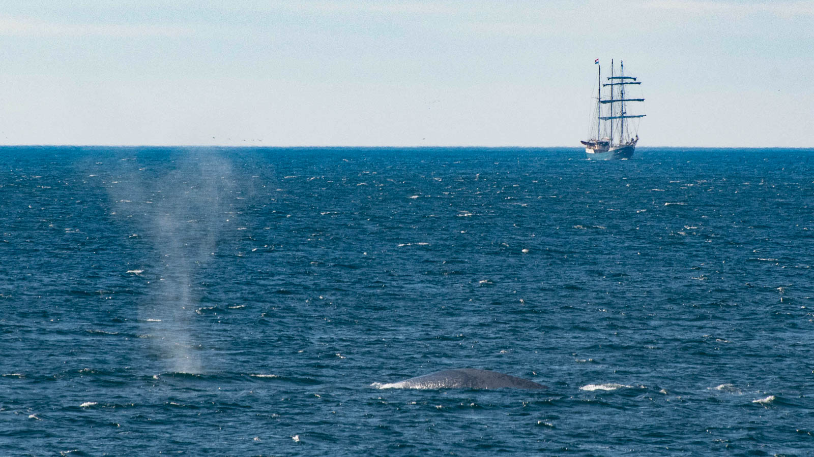
The final treat on the voyage was a brief glimpse of blue whales (the biggest of the whales) around the mouth of the Isfjorden on Svalbard. And a reminder that some people do still sail these seas in boats that are a bit closer to the ones that the whalers used.
 |
| Blue Whale at the mouth of Isfjorden, Svalbard - and a glimpse of more traditional travel |
The voyage really did live up to my hopes. My first objective was to get ashore at Jan Mayen and to learn more about it. Yup. My second objective was to see a variety of north Atlantic whales. Yup. Got that. And my third objective was to see polar bears again. Yes, again.
And the bonus - I think I’m now going to have to promote walrus in my standard arctic talk - they’ve much more interesting than I’d given them credit for. Job done.
And the disappointment. A few lucky people who were in the right place at the right time got a good look at a Ross’s gull (a rare gull, only found in the really far North). I wasn’t one of them. Still, got to keep something for the next trip to the high Arctic.
In all a thoroughly entertaining trip - a fantastic way to escape
the pre-election news and a good way to met some lovely like-minded people. I'm sure Oceanwide will be running a very similar trip next May too, but I'm afraid
I might have used up all the weather luck.