Showing posts with label Cool Places. Show all posts

Pyramiden

The phrase “Russian Mining Colony” doesn’t exactly conjure up a particularly positive set of images.  If you add in “Arctic” it’s very easy to find words like “bleak” and “isolated” coming to mind too.

But for much of the 1970s and 1980s the Russian Mining Colony at Pyramiden on Svalbard was one of the most sought after postings in the former Soviet Union.  The 1200 people (miners and their families) were well paid and very well looked after.  They had access to state of the art medical facilities (and not just measured by Soviet standards), to excellent cultural facilities (including the worlds most northerly grand piano), to fabulous sports facilities (including the worlds most northerly swimming pool) and to plentiful meat and diary (including an indoor farm which produced so many eggs that they were exported to other parts of Svalbard).  They also had access to a (near) 24 hour-a-day dining room and to the most northerly bust of Lenin and their very own KGB station.  All this was provided to encourage miners to come and dig coal from the high-level seams within Pyramid Mountain. 

All this came to an end in 1998 when the people were repatriated and the buildings and mining facilities were abandoned. Over recent years one of the accommodation buildings has operated as a small hotel and there are a few permanent residents who look after the buildings and on occasion provide guided tours.  

Pyramiden lies on one of the northern fingers of Svalbard’s Isfjorden (ice fjord), and as the name would suggest access is dependent on the state of the ice in the fjord.  During the winter it is possible (subject to the weather) to get to Pyramiden by snowmobile, but in the spring this becomes too dangerous and would-be tourists need to wait until the ice is clear enough for tour boats to negotiate the water.  The date when the first boat of the season is able to get through is a very moveable feast, but fortunately for me this year it was 1st June (and I was onboard).

When I’d booked the trip I’d been told categorically that we wouldn’t get to Pyramiden and even once we were onboard the guide was extremely reticent to say anything to revise that view. However on chatting with the crew I was told that over the previous few days the boat (a mini-icebreaker) had been trying to break through the ice and on the previous day had got to within 150 metres of the dock before having to give up.   On our day, I learnt later, two other boats had a look at the ice and decided it still wasn’t navigable, our boat however was able to keep crunching away at the ice until we got alongside the dock.

From the dock we were bussed the short distance to the edge of town and then guided around the town before being given the chance to explore inside a few of the communal buildings.

Welcome to Pyramiden

Downtown Pyramiden from the Isfjord

Accommodation blocks and Pyramid Mountain

Constructed 1972

Some pre-war buildings still exist

Hero Wall - Employee of the Month pictures were once posted here!

Under the boards, heat pipes from the central boiler house

Northern-most Lenin, outside the Cultural Centre

79 Degrees North (and yes polar bears do still occasionally wander into town)

Heated (salt-water) swimming pool

Dining Hall decoration (just in case you forget what it's like outside)

Couldn't find the northern-most grand piano, this upright could have done with a visit from a northern  piano tuner.


North Atlantic Odyssey May 2017

Back in the 19th Century the boats used to set out from the northeast coast of Scotland in search of whales.  These boats used to head up to Shetland and then strike north towards the Greenland coast in search of right whales and humpback whales.

Now-a-days there are still occasionally boats that set out from the northeast coast of Scotland in search of whales.  And as in the past they head up to Shetland and then strike north towards Greenland in search of whales.  There are differences.  The whales being sought are mostly orca and fin and minke whales, and the searchers are armed with big lenses rather than harpoons.  I’m guessing that the boats are rather more comfortable than would have been in the case in the 19th Century. 

Ortelius in Svalbard

I was lucky enough to be on the Ortelius when it left Aberdeen recently heading northwards in search of whales and hoping to be able to land on Jan Mayen island off the Greenland coast, before winding up in Svalbard.

If I’d done a bit a due diligence, I might have found out that in recent years this trip has on occasion suffered from wild sea conditions, seen very few whales and failed to be able to make landings in Jan Mayen.  Sometimes all three.  However when I found that this was a way to visit Jan Mayen, I didn’t do any such due diligence, I just paid my money and assumed that it would all work out right!

It’s nice that such naivety does occasionally pay off. :-)

We left Aberdeen on a calm Monday evening and headed slowly northwards, the Ortelius always heads slowly - top speed is about 10 knots.  By breakfast time the next morning we could see Fair Isle ahead of us, and by 09:30 we were being zodiac’ed ashore into North Haven.  It was a bit odd being 25 miles from the house on Shetland but not visiting there, it was however delightful to be back on Fair Isle, and I think I can honestly say it’s the first time I’ve arrived on Fair Isle not feeling seasick.  The Ortelius may be rather smaller than the Northlink boats that ply between Aberdeen and Shetland, but it is a lot bigger (and more stable) than the Good Shepherd that carries people between Fair Isle and the Shetland mainland.   On Fair Isle both the human and puffin population turned out in force to welcome us, and we got some glorious summer weather too.  

Shetland Puffins
Typical Fair Isle weather

Having had a little taste of Shetland, we were zodiac’ed back to the Ortelius and the serious business of heading north could start.   Jan Mayen was our next planned landfall some 1300 km away.

If the weather is wild this can be a pretty unforgiving area of sea - but if you get lucky it can be smooth and whales, while never easy to spot, get significantly easier to see.   This is particularly true as you get further north and the whales blows get clearer as the air temperature falls.  It’s difficult to not think ‘There she blows’ when you see a blume in the distance, and hearing someone excitedly shout this out loud is still one on of my highlights from the early part of the trip.  One of the bonuses of the slow moving Ortelius is it’s nimbleness in turning when a whale is spotted, and we had several episodes when we were able to get really clear looks at a range of different whales species during the two days it took to get to Jan Mayen.  

Northern Bottlenose Whales
Minke Whales

During these two days we saw big pods of long-finned pilot whales, lots of northern bottlenose whales (including a pair that dived right under the bow of the ship), fin whales and minke whales and orca too.  Cold flat seas are perfect for whale spotting, but when you’re seeing whales several kilometres away it can be pretty challenging to identify them, but I’d think that is something to list under ‘good problems to have’. 

As we had been heading north the expedition crew had been keeping us updated on the Jan Mayen weather.  We knew that we’d had remarkably calm weather south of Jan Mayen, but Jan Mayen is (in meteorological terms, at least) a law unto itself.   The big feature of Jan Mayen is a very large active volcano - Beerenberg.  This volcano rises almost 2300 metres above level, is flanked by a series of glaciers and completely dominates the north end of Jan Mayen - the sheer scale of the mountain and it glacier collection make is a perfect breeding ground for catabatic  winds that can make landing on the few beaches very hazardous. It is claimed that the top of Beerenberg is only clear of cloud on 3 days each year.  It’s my sad duty to confirm that the day I visited wasn’t one of those days.  

Jan Mayen - weather/communication station 
Kvalrossbukta, Jan Mayen

We able to land at two sites on the island, at Batvika on the southern side and at Kvalrossbukta. on the northern side.  Although both landings were completed successfully we did get a brief glimpse of how fast the weather can change, as a rogue wave successfully swamped one of the zodiacs (finally dispelling any ambiguity in what is meant by a wet landing). 

After the second landing we cruised along the mouth of Engelskbukta (English Bay) hoping that we might get a glimpse of top of Beerenberg, but that is going to have to wait for another visit, before again turning north in search of the sea ice off the Greenland coast.  It’s about another 1000 km from Jan Mayen to Longyearbyen in Svalbard, but we opted not to follow a direct route. Instead we continued north in search of ice before turning east to get to Svalbard. 

It’s worth pointing out that this far North at this time of year there is 24 hour daylight - so we were watching for wildlife throughout the 24 hours each day. This meant that the ‘day’ would start with a tannoy message “Good morning, good morning, there are orca directly ahead of the ship”, and just as you were contemplating getting a bit of shut-eye in the evening -  “We think we’ve just spotted polar bears on an ice floe directly ahead”.  Both messages pretty much guaranteed to result in a frantic charge to the ships forward viewing points - and both happened on the same day.

Orca
Bears on Ice

As we headed further north and west we found much more sea ice - but not yet any well-defined ice edge, which is where we might have hoped to find a variety of sea mammals - as the ice became a bit more joined up we found quite a lot of hooded seals (a meal-time favourite of the polar bears) and recent polar bear tracks, but no further sightings of polar bears.

Hooded Seal heading for safety
Bear Tracks

At this point the calendar started to catch-up with us and we needed to head eastwards to get to our dock-date in Svalbard - and as we headed east the weather decided to give us just a little flavour of how things might have been during the rest of the voyage.  An afternoon and evening of rolling through the waves was a reminder that the seas in this part of world aren’t always like mill-ponds.

Stormy Weather

Once through the weather, we again got to flat seas, this time with blue skies too.  Our first Svalbard landing was Prins Karls Forland (an island on the western edge of the Svalbard archipelago).   The objective here was a well known walrus haul-out at Poolepynten where we were able to get up close to a number of walrus.  I’ve visited a couple of walrus haul-outs in this part of the world before and been pretty underwhelmed.  This visit was different - we had a number of curious walrus on the water edge alongside us and they were almost as interested in us as we were in them.  The fact that they were in the water (their element) clearly gave them the confidence to come really close to us - and to stay there too.

Walrus at Poolepynten

We also got a glimpse of the goretex-hooded tourist in the distance - these shy mammals (a little like their penguin cousins in the far south) huddle together for warmth on the ice-shelf.

Tourists

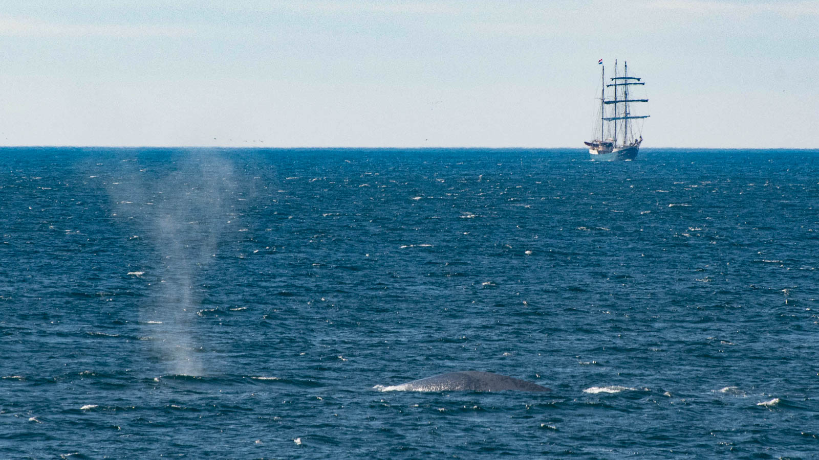
The final treat on the voyage was a brief glimpse of blue whales (the biggest of the whales) around the mouth of the Isfjorden on Svalbard.  And a reminder that some people do still sail these seas in boats that are a bit closer to the ones that the whalers used.

Blue Whale at the mouth of Isfjorden, Svalbard - and a glimpse of more traditional travel

The voyage really did live up to my hopes.  My first objective was to get ashore at Jan Mayen and to learn more about it.  Yup. My second objective was to see a variety of north Atlantic whales.  Yup. Got that.  And my third objective was to see polar bears again. Yes, again.

And the bonus - I think I’m now going to have to promote walrus in my standard arctic talk - they’ve much more interesting than I’d given them credit for.  Job done.

And the disappointment.  A few lucky people who were in the right place at the right time got a good look at a Ross’s gull (a rare gull, only found in the really far North).  I wasn’t one of them.  Still, got to keep something for the next trip to the high Arctic.

In all a thoroughly entertaining trip - a fantastic way to escape the pre-election news and a good way to met some lovely like-minded people.  I'm sure Oceanwide will be running a very similar trip next May too, but I'm afraid I might have used up all the weather luck.

Looking Ahead May 2017

I've been known to spend time peering over the Shetland fence - just to see how the sea and weather change as the days go by.

I couldn't find a convenient fence on the Ortelius, so I had to look out over the bow.

Day 1: 22nd May 18:00 Aberdeen Harbour (and the Northlink Ferry)


Day 2: 23rd May 08:00 Fair Isle in view

Day 3: 24th May 09:00 Heading North - Calm seas

Day 4: 25th May 05:50 Still Heading North - Bit misty this morning, but even calmer seas

Day 5: 26th May 09:40 Approaching Jan Mayen Island - Cloud down on Beerenberg

Day 6: 27th May 07:15 North of Jan Mayen, in search of sea ice

Day 7: 28th May 06:50 Finding sea ice

Day 8: 29th May 08:00 Still calm, but warnings of trouble head

                            16:20 Trouble arrives

Day 9: 30th May 06:00 Blue skies and sunshine, and Svalbard ahead

Day 10: 31st May 06:30 Approaching Longyearbyen, Svalbard

Heading North May 2017

This should have been a weekend of at least mild panic.  The Headington bit of Oxfordshire Artweeks starts next Saturday (20th May) and in each of the last three years I would have been running around getting pictures framed and hung and trying to get the house into a state where visitors could be invited in.

But not this year.  

This year I’ll be running away to sea.

This weekend I’m getting my wet weather, cold weather and photography gear ready to do a trip I’ve wanted to do for a while.  Next weekend I’ll be heading up to Aberdeen and then getting a boat to the Shetland Islands.  

“So what?” I hear you cry.  “You’ve gone up to Aberdeen and got a boat to Shetland more times than I can remember”.  

This trip is a bit different.  

Aberdeen
Fair Isle

Instead of getting onto one of the Northlink boats in Aberdeen, I’ll be joining the MV Ortelius run by Oceanwide Expeditions and heading to Fair Isle, about 25 miles from my house at the southern end of the Shetland Mainland.  From there the boat will turn north, crossing the Arctic Circle until we make landfall on the remote island of Jan Mayen at almost 71N.  This little island is home to an isolated Norwegian weather station and Beerenberg, a 7,500 ft high active volcano.

After a little bit of time on Jan Mayen, when hopefully we’ll have seen the top of the volcano (although statistically this is extremely unlikely) it’s north across the Greenland Sea and into the high Arctic.

Jan Mayen
Next stop is Spitsbergen (79 North).

Spitsbergen

So why has this trip been on my must-do trip for a while?  

It should let me see a variety of whales (including orca, fin, bowhead and minke) as well as polar bears, seals, walrus and arctic fox.  It should let me add another seriously remote location to my island list (and spend a few hours on Fair Isle too).  It gets me back to Svalbard, complete (at this time of year) with 24-hour daylight.  

Perhaps most importantly it will let me experience the gradual transition from the (relatively) mild maritime conditions around the Scottish coast at 57 North to the full arctic conditions at 79 North. I’m interested to see how the weather changes, and when during the voyage we first encounter ice.

The last time I went to Svalbard I jumped from London via Oslo to Longyearbyen enclosed in an ‘airline bubble’ so the transition was a step change rather than the slow change I hope to see this time.

It would be lovely to be able to come back south by boat too, but unfortunately that would involve staying around Svalbard until the autumn when the tourist boats come back south again so my return journey will be in the airline bubble.


Ilulissat, Greenland, September 2016

My first visit to Ilulissat was as a stop-off point along the Greenland coast on the way into the Northwest Passage.   My recollection was of being somewhat underwhelmed by the Ilulissat weather - which could most charitably be described as dreich.  It’s taken me a few years to sort a visit back to the west coast of Greenland to see what the weather can be like!  This time I spent a week in and around Ilulissat - with near-cloudless blue skies every day, and the one brief shower of rain was snow!

Sunny afternoon on the Ilulissat waterfront

Ilulissat is the tourist centre of Greenland - the business and administrative centre is Nuuk a few hundred miles to the south, but the tourist magnet is Ilulissat and particularly the Icefjord on the southern edge of the town.  The Icefjord was designated as a UNESCO World Heritage Site in 2004, and has been key to many tourist activities developed in the town to complement the traditional hunting and fishing industries.

The vast majority of the town’s tourists arrive on cruise ships throughout the summer - almost all are little expedition cruise ships, but occasionally larger ships are now adding Ilulissat to their itineraries. The arrival of even a small ship transforms the town, filling the streets with yellow- or red-clad visitors depending on the boat visiting.  Having been a red-clad visitor in 2013, this time I was in town as an independent ground-based tourist.  

There are a limited number of routes to Greenland.  In 2013 I flew into Kangerlussuaq on a charter flight from Ottawa, this time I flew in from Copenhagen on Air Greenland’s only big red plane.  From there I caught one of their little red planes into the little airport just outside Ilulissat town.

Changing from the big red plane to a little red plane

The recent surge in ground-based tourism does rather seem to have out-paced the development of hotel rooms.  I struggled to find somewhere to stay for week in July or August, so I wound up booking a little apartment in the town centre in September.

September is definitely the end of the Summer season - the temperatures are significantly lower (mostly around freezing), but the real plus is that the falling temperatures see off the mosquitoes and black flies which can make wandering in the Arctic unpleasant in summer

With one or two minor exceptions you can walk pretty much anywhere you want in hills and valleys around Ilulissat, but the local hiking clubs have defined a series of way-marked routes going from the town to various points along the northern edge of the Icefjord.

The Ilulissat Icefjord
Iceberg Tourism

The Icefjord is a deep inlet from Disko Bay reaching right up to the edge of Greenland Icecap about 70 kms inland.  This channel is the most ‘productive’ single route for Greenland ice to get to the sea accounting for 7% all the ice output (this equates to an implausibly large number of tons of ice flowing out to sea each day).  Traditional anecdote suggests that it was an Ilulissat iceberg that met with the Titanic in 1912.  

The settlement at Ilulissat has been around for about 275 years, but people have lived near the Icefjord for thousands of years - the bay at Sermermuit just beside the Icefjord has evidence of houses almost 4000 years old.

Sermermuit

The glacier front has been moving inland quite dramatically over the last few years, but the appearance of the icefjord has been pretty much unchanged. For most of its length the fjord is well over 1000m deep, allowing even huge icebergs to calve from the front of the glacier.  Having calved the icebergs are then free to float towards the sea.  Or at least they would be were there not a seabed ridge at the mouth of the fjord. This ridge blocks the big bergs from reaching the sea and in turn leads to fantastically dramatic iceberg traffic jam backing up the entire 70 km length of the fjord.

Iceberg front at Disko Bay

From one of the viewpoints outside the town you can see the front of the queue, which at times is a 10km line of icebergs across the entire width of the fjord.  At a glance (or two) everything looks pretty static but if you return day after day you will notice that new icebergs have broken free and are now making their way out into Disko Bay (no doubt aspiring to make their mark as in 1912).

Occasionally as you sit watching the ice you might just hear a crash of ice somewhere in the distance, and if you get really lucky you might just see one of the bergs at the front of the queue disintegrating as the pressure from behind finally gets too much. 

Crumbling Ice

The crash of ice isn't the only thing you’re likely to hear around Ilulissat.  

If you sit quietly you might also both see and hear one of the many humpback whales around the bay coming up for air. The seabed around the fjord mouth is constantly being churned up by the icebergs crawling their way across the ridge - this make the waters around the fjord incredibly fertile - which means lots of food for marine life right up the food chain, including both whales and the local fishermen.  So if you can’t hear a whale blowing you’re probably going to be able to hear an boat motor somewhere on the water.

Humpback whale - Disko Bay
Fishing

The other sound that characterises Ilulissat (and most other Greenlandic towns) is of the dogs.  Ilulissat has a resident population of about 5000 people and about 6000 dogs.  During the winter the dogs eat well and work hard pulling sledges - but in summer they don’t get so much to eat (they wouldn’t work it off!) and they are chained up on the edge of town.  This makes the dogs a little bit cranky, and once one starts howling its very likely that the other 5999 are going to follow the lead.  

The one except to the chained-up rule are the young puppies.  The puppies get one summer where they can wander at will around the town causing the mischief that you would expect from a couple of hundred puppies!

Pups on the Loose

The other bonus of visiting places like Ilulissat in the autumn is that it gets dark!  In summer you get 24 hours of daylight, but in September you get both sunrises and sunsets.  And if you get really lucky you’ll get a display of the Northern Lights too.

Disko Bay Sunset

Most people who visit Greenland do so as cruise ship passengers - this undoubtedly makes the visit logistically easy (although not cheap) and means that although you get to see lots of places you only get a glimpse of each.  Visiting Greenland as a ground-based tourist is easy to do and means that you get the chance to spend longer in places - and also to see them without the crowds of other tourists. I’ll certainly be back in Greenland at some point again.