Showing posts with label Overseas trip notes. Show all posts

In Search of Strudel around the Tiernsee, May 2016

Before you reach for your atlases, the Tiernsee doesn’t really exist.  

It was invented by Elinor Brent-Dyer at some point in the 1920s, and was one of the settings used in a series of books published over many years in the middle of the 20th Century.  The “Chalet School” books were partly set around the shores of a fictional lake, the Tiernsee, in the Austrian Tyrol. EBD (as, I gather, she is referred to by fans) didn’t rely entirely on her imagination to conjure up the Tiernsee, she based her stories around memories of a long visit she paid to the Achensee (which really is in the Tyrol) in 1925.


I’ve never read the Chalet School books although my other half has done so repeatedly - but when the opportunity to visit the Tiernsee/Achensee arose I wasn’t going to turn down the invitation to spend a few days wandering up Tyrollean mountains. And besides, I was promised Apfelstrudel.

The Achensee is in a valley above the Inn Valley in western Austria.  Pretty much everyone who wants to visit the Achensee will wind up coming through the little town of Jenbach in the Inn Valley.  Our route across Europe by train had involved going through St Pancras in London plus Brussels, Frankfurt and Salzburg before we pitched up in Jenbach.  We could have completed the journey to Pertisau on the lakeside using the a funicular railway and the same engine and carriages that EBD (and numerous fictional school-girls) had used and one of the rather more modern lake steamers - but our hotel sent a minibus to collect us.


In addition to the lakeside, the valleys and mountains around Pertisau provide lots walks of all sorts. Ranging from flat-and-surfaced stroll through to fairly extreme climbs - we stuck mostly to the softer end of the scale.  

One of hazards of walking in the Alps is the profusion of guest huts strategically placed around the valleys and tops. In the UK mountain walking inevitably seems to involve stops huddling behind dry-stone walls hoping that the wind will drop for long enough for you to peel the clingfilm from a battered sandwich.  In the Alps the challenge is deciding if you want beer with the schnitzel-of-the-day or coffee with the strudel-of-the-day.  While the strudel-fest is certainly welcome it does rather defeat the feeling of braving the elements, and one of the huts we stopped at even had a vintage bus service if the post-strudel stroll back down the valley looked too challenging.


If the valleys and the tops seem too much, there is a lovely walk along the lake edge that goes right around the lake, and better yet you don’t need to do it all at once.  The regular little steamers chug up and down the lake all day, picking up and dropping off at regular points around the lake.  There’s usually somewhere to buy coffee at each pier - and there’s certainly beer, coffee (and strudel) on offer on the boat too.


Which brings me back to subject of strudel.  I was lured onto the trip by the promise of Apfelstrudel and I can certainly bear witness to the quality of the local strudel. If you’re taking notes, the Gramai Alpe guest-house had the best Apfelstrudel.


However, I did discover that there is something better than Apfelstrudel on most menus - Topfenstrudel just like Apfelstrudel but filled with curd cheese and raisins.  If you're offered it, you should try it.

We spent a very pleasant week staying on the edge of the Achensee - and we certainly hadn’t run out of walks to do.  Next time I’ll want to go back for a bit longer, and it would be fun to go back in winter and to do some of the walks on cross-country skis.  


And I’m sure there are a few strudel-stops I missed on this visit. 


If you want to visit the Achensee (knowledge of the Chalet School is optional) - try InnTravel.


Down Under, November 2015

Melbourne - Ideal place for a city break.  

Lovely riverside location, great weather in November, fabulous coffee and excellent food. Only real downside - it’s a 21,000 mile round trip from the UK.

I got to spend a week there - and it did involve an awful lot of time spent sitting in economy-class seats on very large planes!

Bit big these Airbus 380s

Central Business District

I was staying in the Melbourne CBD near the banks of the Yarra River - an ideal place to stay if you want decent coffee, good restaurants and a splendid choice of skyscrapers.

Yarra River Footbridge, decorated ready for Christmas
Federation Square from the top of the Eureka Tower 
Evening by the Yarra River
Skyscraper Melbourne

Monash University

My excuse for a few days in the heat (and it got up to 33C one day - which is rather warmer than I like) was to spend time talking with folks from Monash University.  This meant that I got to spend time around the Monash Campuses at Clayton and at Caulfield.

Caulfield Campus, Monash University 
Clayton Campus, Monash University

St Kilda

My one day of escape from work (or the city centre) was to head out to the seaside suburb of St Kilda - partly to see if I could see any similarities with it’s Hebridean namesake (I couldn’t) and partly to see if I could spot a few of the Little Penguins that lurk in the St Kilda Breakwater (I could).

Little Penguins in the St Kilda Breakwater 
St Kilda boats with the Melbourne skyscrapers behind
St Kilda pier

And at this time of year there really is no escaping the approaching holiday season - although I gather the odds on a White Christmas in Melbourne are pretty long.

Seasons Greetings at Flinders Street Station


Lofoten Islands, May 2014

My first visit to the Lofoten Islands was in February 2012. That visit was dominated by snow.

Svolvær , February 2012
There had been some snow before I got there, but as I arrived the snow started falling seriously.  The upshot was that I didn’t get to see too much of Lofoten. The tops of the mountains were mostly covered in cloud, and the roads were entertaining to drive on. I did, however, see just enough of the mountain tops, and just enough of the villages near Svolvær to ensure that the Lofoten Islands stayed firmly on my must-visit list.

This time I arrived in Lofoten, after crossing the Vestfjord from Bodø, in bright sunshine.   My plan (assuming typical island weather) had been to hire a car to provide both transport and shelter.  The weather that appeared meant that the only shelter I really needed was a sun-hat, so I reverted to a boot-and-bus travel plan.

Rorbu on Svinoya
My first base in Lofoten was Svolvær, the biggest town in the islands. This doesn't make it a metropolis but does mean a choice of places to stay, and a choice of places to eat.  Svolvær doesn't have the charms of some of the villages further down the coast, but it does have the administration, communication and industrial facilities that are needed to make life in a remote group of islands in the Arctic possible. It also has a fantastic setting that will set the heart-beat of any would-be mountaineer soaring.  For other tourists there is the draw of fjord safaris, looking for whales and white-tailed eagles, and the island of Svinoya linked by bridge on the other side of the harbour.

Fish drying racks (hjell) on Svinoya
Svinoya is covered with red-painted rorbu, and huge numbers of triangular hjell (mirroring the shape of the mountains) used for drying cod each winter to transform it into stockfish.

In the evening, there is also a museum in Svolvær, telling the story of the Second World War in the Lofoten Islands. It's a very busy, and fascinating, little museum. And why in the evening? Lots of towns along the Norwegian coast base their activities around the Hurtigruten ship timetable, Svolvær is no exception. Both the north-bound and south-bound ships call in the evening and for 3 or 4 hours the town is filled with Goretex-clad visitors eager to visit anything that's open.
Lofoten Cathedral, Kabelvåg 
Just south of Svolvær are the villages of Kabelvåg and Henningsvær.  Kabelvåg known for its unique island cathedral and for a pair of museums, the Lofoten Museum telling the story of the islands themselves, and the Lofoten Aquarium telling the story of the waters around the islands.

Harbour, Henningsvær 
Henningsvær sits a little further along the coast, on a little group of islands linked to the 'mainland' by high arching bridges. Henningsvær fits a lot of the Lofoten stereotypes.  A collection of mostly red-painted wooden houses around a harbour filled with boats, with snow capped mountains behind, and racks of drying fish on almost every available piece of ground.

Henningsvær 
The one piece of ground exempted from fish drying around Henningsvær, is the football field, and it’s surrounded by fish racks rather than terraces for the supporters.

Tunnelsyn, Skrova
A few miles across the Vestfjord from Svolvær is the island of Skrova. This little islands claim to fame is as home to one of few remaining whaling boats still active along this bit of coast. The island is, like many around Lofoten, reliant on catching and processing fish. I did see the whale boat when I was visiting, and was relieved not to see it at work.  The history of Skrova is told through the eyes, or more correctly the lenses, of local photographers in a wonderful exhibition called Tunnelsyn - Tunnel Vision - which really is in a (mostly unused) tunnel. It's a long time since I was encouraged to wear a hard hat to look at photographs.

Å i Lofoten
My southern base in the Lofoten islands was the little village of Å (or Å i Lofoten, if you want be sure not to mix it up with other places called Å).  This really is a small place. Especially out of season. There is somewhere to stay, the youth hostel. And if you’re prepared to walk the 3 km to the next village, Sørvågen, there is somewhere to eat. So why would you come to Å? You might come to visit the world’s only Stockfish Museum. You might come to visit the Fishing Museum. But for most people they come simply because it’s the end of the road.

The E10 starts at on Baltic Coast in Sweden in the town of Luleå, winds across northern Sweden and then into Norway where it comes King Olav V’s Road (as well as the E10).  From the Norwegian border the road heads to Narvik before crossing the Tjeldsund Bridge and onto the Lofoten Islands. A network of tunnels and bridges carry the road through the islands to a final tunnel just outside Å, which provides a dramatically situated car park and turning circle.  South of that are a few faint footpaths (not all suitable for the faint-hearted) up into the mountains but otherwise no way further south other than by boat.

Beyond the Road, Å i Lofoten 
Back up the road are a series of implausibly picturesque villages – at least they are when they are bathed in sunshine under blue skies and backed by snow-capped mountains.

Sørvågen boasts supermarkets, an excellent little restaurant and a telecommunications museum (at some times of the year).  This unlikely museum is a nod to Norway, Lofoten and particularly Sørvågen’s place in telegraphic history. In 1903, just four years after Marconi demonstrated wireless communciations, there were large scale experiments going on Sørvågen providing communications to the outlying Lofoten Islands.

Reinefjord
Both Moskenes and Reine have been built around natural harbours. Moskenes has a seasonal tourist office, a single restaurant and ferry connections to the Norwegian mainland, and Reine on its own little peninsula at the mouth of the Reinefjord.  There are several isolated hamlets around Reinefjord, and the best (maybe only) way to see these and to explore the fjord is to hop on the little ferry that goes around the fjord two or three times each day delivering hikers, shopping and post as it goes. If you’re lucky you’ll also get a good look at the resident pod of orca that live in and around the fjord.

My second visit to Lofoten really did confirm my initial impression that this is a special place. The dramatic mix of mountains and fjords, of villages and harbours, combined with the clear, crisp air that gives the light a special quality makes Lofoten a wonderful place for photography.  I'm certainly going to be back again.  I've explored a few of the towns and villages but there are many more to explore.

I do think I'm going to need to do a little bit of personal expectations management about the weather ahead of my next trip.  The odds on getting another couple of weeks to match the two I've just had must be pretty long.

My photo diary for the trip (on Blipfoto) starts on 3rd May when I arrived in Svolvær, and there is a selection of images from trip on Flickr too.

If you want to revisit my earlier trip which had more snow and more aurora but much less sunshine is elsewhere on Flickr.

Petra - The Rose-Red City


There’s a bandwagon around – it's 200 years since Petra was rediscovered – so I thought it was time to jump on.

If you’ve been fortunate enough to spend a few days working in Amman in Jordan, and it’s a few days until your next meeting, there probably isn’t anything better than to hail a taxi, and head south to Petra.

Getting to Petra

There are two roads from Amman to Petra. There’s the new Desert Highway which goes straight to Ma’an, before turning off to Petra and Wadi Musa which takes about three hours, and there’s the old Kings Highway which twists and winds its way past a series of little towns and crumbling castles which takes much longer. My taxi driver wouldn’t hear of my using the Desert Highway for my first visit to Petra.  He was insistent that to see the real Jordan you needed to do what travellers to Jordan have been doing for hundreds of years, and follow the route of the ancient Kings.  True to his word we stopped at crumbling crusader castles at Karak and Shobak, we ate fresh hot bread from roadside bakeries, we went through the Wadi Mujib, we looked for (and found) black irises on the roadside, we visited the Dana Nature Reserve – and to top things off I wound up being dropped at the Crowne Plaza Resort Hotel in Wadi Musa.  I’d picked this hotel from the internet – and the feature in the description that got my attention was ‘200 metres from the entrance to the Ancient City of Petra’.   The hotel didn’t disappoint and I spent the evening sitting on a hotel balcony looking out onto the hills that surround Petra – the hills that give absolutely no clue as to what they are hiding.   Johann Ludwig Burckhardt probably sat somewhere nearby, albeit it in less comfort, in 1812 and wondered what he was going to see when he was taken into the city.

First Sight of the Treasury

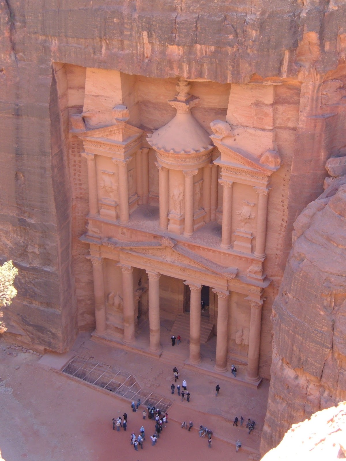
The real benefit of having a hotel close to the entrance is getting in early.  I was going to be able to spend two full days (plus a short visit early on a third day) around Petra, so I was first in line when the ticket office opened to get my three-day pass, and to start on the short walk down towards the gateway into the Siq.  The Siq, the narrow passageway into the city, and the Treasury at the far end of the Siq, feature in all the guide books to Petra and you might think that this would take away any novelty or excitement. It doesn’t.  The Siq draws you gradually down into the city.  As you follow each twist and turn, you hope for a first glimpse of the Treasury.  If it’s early in the morning you might disturb a few birds and the only sound is likely to be that of your own footsteps on the rock.  Eventually the Treasury appears between two curves of rock, looking exactly like it does in the guidebooks. But bigger.  And redder.

What the guide books really don’t prepare you for is the sheer scale of Petra.  The buildings, which were famous even before Indiana Jones visited, are spread out over a huge area, and over quite substantial mountains.

There are several different areas within Petra, some dating back to the Nabataeans, others to the later Roman occupation of the site.  The temples and tombs from the earlier period are in some places amazingly well preserved – the Treasury at the end of the Siq, and the Monastery high above the main (Roman) city centre being the most dramatic.  The sequence of elaborate tombs carved into the cliffs also raise graveyards to a whole new level of grandeur.

The High Tops

Once you’ve seen the Treasury and the city centre, it’s time to start climbing.  The Monastery is the most visited of the remote sites, and in addition to the dramatic façade, the climb and the cliff tops beyond give fantastic views across southern Jordan.  On the other high points are dramatic sacrifice sites, some looking down onto the dramatic fascades.  My favourite was Al Madbah, or the Place of High Sacrifice. Some of the routes are easy to follow up staircases and well-marked paths, other are much less obvious and make the map you’ve been carrying worthwhile.

People

Until 1985, when Petra was added to the UNESCO World Heritage Site List, there were still people living in the caves around the old city.  Part of the deal for being added to the list was that the residents would be provided with a new village outside the old city boundary, which had things like electricity and water.  The other part of the deal is that the former residents were given permission to come into the old city and continue to act as guides or to run stalls and shops.  They do all these things, and also give the interested visitor the chance to talk about living in the caves.  Some of the residents were happy, and able, to talk in English and to tell me that the new houses weren’t as good as the caves.  The houses were too hot in summer, and too cold in winter while the caves stay at the same comfortable temperature all year round.  Other residents weren’t able to talk much English, but were still very able to communicate.  My strongest memory was encountering a young goat herd on one of the hill tops.  He gestured me over to the little camp fire he had nearby, and insisted that I have tea with him – we weren’t able to talk but I really enjoyed just spending a quiet few minutes sitting with him before I headed back to the crowds around the main sites.

Petra by Night

There are lots of tourist things to do around Petra, but if you only opt to do one thing to complement the walking and wandering, you should visit Petra by night.  The site closes at dusk, but on a few evenings the site reopens again after dark.  You are guided down to the entrance to the Siq by torchlight then left to find your own way down the Siq which is lit from end-to-end by candles, and around the Treasury, which is also lit by hundreds of candles, local musicians play.  I’m not sure that this really gives a realistic picture of which life might have been like in Petra, but it does give your imagination plenty to work with.


Logistics

Petra is really easy to reach from either Amman in the north of the country, or from Aqaba in the south.  Organised trips to Petra run from the big hotels in both cities, but only give you a very short time in Petra.  

There are lots of hotels in/around Wadi Musa, and although all the hotels offer lifts to the entrance gates, however I think there is a real plus to being within walking distance.  This makes it easy to get in early each day, and to be ahead of the crowds.  Petra does get busy, so go early – when it’s both cooler and quieter.

Two days is barely enough to see the big sights, and get a feel for the place, so if you can manage three days do.  By the time you add in the climbs to the various temples sites around the hills you are likely to be pretty tired and foot-sore.   When I go again I’m going to take decent  walking boots, and if the final walk back up the Siq to the hotel is just too much, there are always going to be local taxis to take the strain.


Faroe Islands February 2012


It really ought to be easier to get here.

Torshavn, the picturesque capital town of the Faroe Islands is only 230 miles from Lerwick, the only slightly less picturesque capital town of Shetland.  There used to be a boat between the two - but that got cancelled, for reasons that I've never seen adequately explained, a few years ago. There used to be a plane between the two, but that also stopped a couple of years ago apparently it's foggy too often in the summer in Shetland.  Nowadays to get to the Faroe Islands from Shetland requires a long (and expensive) detour via the UK mainland and Denmark.  Of course my route had been even more circuitous taking in Oxford, Stockholm, Oslo, Bergen, Tromso, Kirkenes, Narvik and Gothenburg before I got to the Atlantic Airways check-in desk at Copenhagen Airport.

I really couldn't help but compare the folks in the departure lounge with the folks I usually see in the Edinburgh departure lounge on my way up to Shetland.  All the regulars were there - the business people and the local politicians, the shoppers and families loaded with packages (does any airline - other than Ryanair- enforce the one bag rule?) and a few tourists (February can't by any measure be called peak tourist season) usually equally laden with backpacks and camera bags.  The other similarity is the hospital cases - it's not unusual to see people on Shetland flights on their way to or from hospitals on the Scottish mainland, and although there weren't any obvious hospital cases on my flight to Torshavn I did get re-seated so that the plane could be reconfigured to carry a stretcher which was going to be needed on the return flight into Copenhagen.

The flight from Copenhagen takes a little over 2 hours which is enough time for Atlantic Airways (the Faroe national airline) to offer sandwiches and drinks and (unlike Loganair) the duty-free trolley, definitely more traditonal full-service rather than budget airline.  The flight route crosses just north of Shetland - heightening the sense that it should be easier to get between there and Faroe.

The approach into the airport at Vagar immediately triggered déjà vu moments. At one moment the similarity with Shetland was obvious, and at other moments I was back on the approach to Keflavik in Iceland.  Once on the ground, it was clear that the airport was more like Sumburgh than Keflavik (albeit with a duty free shop attached).  It was easy to distinguish between the locals returning home and the tourists arriving.  The arriving tourists stood around waiting for the baggage carousel to come to life, and the locals all piled into duty free to stock up before facing up the Scandinavian-priced booze elsewhere on the islands.

My bus ride from the airport again had Shetland moments to it.  At the airport lots of people climbed on having stowed cases and backpacks under the bus, however as soon as the bus left the airport it immediately became the local bus service into Torshavn, stopping in lots of villages to let school kids and housewives get into town.  The big difference between modern-day Faroe and Shetland became apparent about 20 minutes into the journey as we plunged into a long tunnel. Like Shetland, the Faroes is an archipelago of both large and small islands, but unlike Shetland almost all of the main populated islands here now have fixed links using tunnels or bridges.  The airport is on the island of Vagar, and where there used to be a ferry to the 'big' island, Streymoy, there is now a tunnel.  The building of the bridges and tunnels has made a huge difference to the islands, the often weather delayed journeys between the islands heightened the isolation of, particularly, the more remote communities.  The links have made everything feel closer together.  The tunnel digging hasn't just made it easier to get from one island to the next, it has also allowed communities on opposite sides of the steep mountains to reach each other much more readily.

In any group of remote islands (and I've been to several over the last few months) weather is a big deal - and the Faroe Islands are definitely in the front line when it comes to facing up to the north Atlantic storms.  Over four days I saw every weather variant bar snow.  I saw bright sunshine. I saw torrential rains. I saw steady drizzle. And I saw winds strong enough both rip off car doors (if you weren't careful) and to ensure that water 'falls' went upwards.  But when the clouds did clear, it was really easy to see the scenic attractions of the Faroe Islands; long narrow twisting fjords separating steep rocky mountain peaks.

The main traditional industries in Faroe are, like so many remote islands, based on the surrounding seas.  I don't think there is (yet) an oil or gas element to the economy, but fishing has always been a big deal.  Fishing in the north Atlantic certainly doesn't fall into the catalogue of safe jobs, and every community round the Faroe coastline seems to have a legacy of fishing disasters.  In many of the villages this is symbolised by statues, some poignant representations of waiting women and children looking out to sea, in other cases showing boats being dragged down (or carried aloft) by shoals of fishes and in yet more cases modern statues commemorating both local fishermen and other fishing communities further afield. One of the really dramatic aspects of the memorials are the long lists of names associated with particular disasters.  When you stand in a little village with no more than 10 or 20 houses looking at a list of 20 young (and not so young) men, you can only imagine what trauma the accident would have had on the community.

One other maritime tradition in the Faroe Islands that is pretty hard to stomach, particularly since it is still going happening, is whaling.  I saw no direct evidence of it while I was there, but the grindadrap does still happen.  This is a whale hunt where pilot whales are driven onto a beach and killed in huge numbers.  Shockingly there is a Shetland parallel here.  There are photographs in the museum in Lerwick showing hunts of this sort happening near our house in southern Shetland in the early years of the 20th Century.  The only real defence is that at least the Shetland folk have stopped doing it now. As an outsider it's very easy to dismiss the hunt as barbaric and out-dated, but it's still important as a Faroese tradition, albeit one that I'd be delighted to see stopped.

I had time to explore the two biggest Faroe islands - Streymoy and Eysturoy - in addition to having a brief look at Vagar, as I went to and from the airport.  The strongest memories are of the remote villages at the north and south ends of each island – such as Eidi and Gjogv on Eysturoy and Tjornuvik and Kirkjubour on Streymoy.

One thing that continued to surprise me throughout my travels in Scandinavia this spring is the Second World War history.  I knew that Norway and Denmark were both occupied, I'd heard of Vidkun Quisling and I was vaguely aware (presumably from Sunday afternoon movies) of the 'heavy water' story and the Heroes of Telemark, but that was about the extent of my knowledge.  There's a much longer blog post in there somewhere, but suffice to say that my knowledge of the Faroe Islands  wartime history was definitely very sketchy.  The islands were occupied by the British in early 1940 as a precaution, just after Germany invaded mainland Denmark.  Before the war, the Faroes were effectively a 'county' within Denmark, after the British invasion the islands needed to assume a lot more autonomy.  In many ways this was forced on the Faroese at the time - to the extent that British warships tracked down Faroese boats and ordered them to get rid of their Danish flags and replace them with Faroe ones.  At the end of the war this autonomy was (eventually) formalised after Denmark regained its independence.

There is still a legacy of the British invasion, although the practice of driving on the left on Vagar did eventually get reformed.  The airport is still inconveniently long way from Torshavn - the location was picked on the basis of the difficulty of attacking it from the sea rather than on what was likely to be useful for tourists after the war.  And there's still Cadbury's Dairy Milk on sale in the shops. The British troops seem to have handed out enough chocolate to hook the Faroese population for good.  I guess they were lucky that it wasn't the Americans that invaded, I can't see Hershey's chocolate having such a long-term legacy.

I had a really good time wandering around the islands, and I certainly hope I can figure out a way to do a much longer stay in the islands – and next time I’ll try and get back in the birding season when I can go and have a look at the cliffs at Vestmanna and on Mykines.

My favourite place on this trip was, I think, the village of Tournivik at the north end of Streymoy. This village was one of the last places to be connected to the Faroe road network, and sits in a perfect 'botnur', a circular glacial valley, looking out towards the sea stacks and cliffs at the northern end of Eysturoy.

A little bit about logistics.  I flew from Copenhagen to Faroe on Atlantic Airways. They fly between mainland Denmark and the islands four or five times each day, the flight takes just over two hours.  While on the islands I stayed in Torshavn at Hotel Streym - this is a small modern hotel just beside the harbour - it's very comfortable and they do a really good buffet breakfast.  The hotel also has a number of hire cars available - which are good value.  I can't say much about Faroese cuisine, but my restaurant recommendation for Torshavn is the italian restraurant Carrello which overlooks the harbour just round the corner from Hotel Streym.

There are more pictures from the Faroe Islands on my Flickr stream

Scandinavia February 2012

I've finally had the chance to work through the collection of photographs I took on my Scandinavian tour in February 2012.

There were four phases to the tour.

1.  Following the railways along the 60N line - starting in Stockholm (59.3N), going west to Oslo(59.9N) and then to Bergen (60.4N).  Flickr.

2. Going North (and East) along the Norwegian coast on the Hurtigruten ship MS Lofoten, from Bergen to Kirkenes (70N, 30E) then back South to Svolvaer in the Lofoten Islands. Flickr

3. Exploring the Lofoten Islands (based in Svolvaer) Flickr

4. Exploring the Faroe Islands (based in Torshavn) Flickr

Oslo, February 2012

Oslo is a major tourist destination but, fortunately for me, not in February. The competition in the museums wasn't from coach loads (or, worse, cruise-ship loads) of camera-toting tourists, but from legions of back-pack-wearing primary school kids.

I decided to stick to my maritime tourist theme for this trip and after wandering along the snow-covered quay sides, found a bus to the museums ghetto on Bygdoy peninsula a few miles west of the city centre. In the summer there is a ferry across the fjord to Bygdoy, but at this time of year the 'only way is bus' - as the young women in the tourist office assured me. Since the bus is the only way, it's the route that the school groups take too. The seven year old (I'm guessing) sitting beside me was happy to chatter in English about his school trip to see the Viking boats - his English being very much better than my Norwegian.

I paid a quick visit Roald Amundsen and his polar colleagues - the five of them are cast in bronze and stand looking gravely down the Olso Fjord just outside the Fram Museum - before going to see the Fram, the ship that Amundsen used on his successful trip to the South Pole in 1911. The boat itself is very similar to the Discovery I've visited a few times in Dundee, but despite being out of the water the Fram is in a much more original condition than the Discovery.

Fram was declared a museum piece in 1925 and retired when it was still pretty much in its original state when Amundsen moved on to his next ship. The Discovery went through several users who changed it to meet their needs before finally being properly 'retired' back to Dundee. I have visited the Fram before (almost 40 years before) but my recollections are I think mainly from the family photographs rather than being 'real' memories. The Fram museum has been through a major refurbishment recently, now it includes sound and light special effects (wind noises plus quite good Northern or perhaps Southern Lights effects). As well as visiting the far South Fram still holds the record for the Northern-most point reached by a wooden ship. There is also a 'freezer' room in the museum with a moving deck to give the passing tourist the sense of what the weather in the far North (or South) might be like when on board. It's probably quite dramatic at the height of summer, but is of limited impact for someone who's just arrived from Stockholm in February. Having seen and heard the Scott Centenary events in the UK, marking both Scott's reaching the South Pole in early 2012, and his death a few weeks later, it's very noticeable that all the similar Norwegian hoopla and souvenirs go big on 2011 being the Centenary.

Just next door to the Fram is the Norwegian Maritime Museum, which covers about 2000 years of water-borne history from dug-out canoes though to specialist oil rig vessels and bulk carriers and has examples of some of the older, smaller boats plus fantastic models of the bigger and newer vessels. There is a really good video presentation that flies you along the Norwegian coast from the Lofoten Islands round to Oslo, and combines both modern (helicopter-shot) video footage with historical photographs from the early 20th Century.

A little further back towards the centre of Oslo is the Viking ship museum - which houses three original Viking longships from various parts of Norway. All three were used as funeral vessels, and were buried with everything needed for the next life. Two of the ships look as if they could, once the ice had cleared, be moved off to the closest fjord and sailed away.


Three museums is my limit for one day, so my final stop in Oslo was Akershus Fort in the centre of the city, with beautiful views over the harbour, the city and along Oslofjord too, which almost, but not quite provided a sunset.


Just to round off the maritime tone that the trip is taking on, I walked past a rather smart looking motor yacht called Norge just below the walls of the Akershus - it's the Norwegian Royal Yacht. I'm told that this is one of only two Royal Yachts still in service in Europe, the other one is Danish.

Stockholm, February 2012


The first stop in what could turn out to be a maritime themed tour of Scandinavia was Stockholm.  A very quick train ride in from the airport on the Arlanda Express saw the temperature drop steadily from about 0C at the airport to -10C as we got into the centre of town.

I had been looking for somewhere to stay in the old part of Stockholm, Gamla Stan, which has lots of character and is very close to the main train station, when I came across the Malardrottingen.  Originally called the Vanadis, this old motor yacht was the 18th birthday present for one of the members of the Woolworth family, it's now a small hotel moored on the island of Riddarholmen just beside Gamla Stan.  Very comfortable, with a great view across the sea ice from the porthole in my cabin.


The sound of the sea ice grinding against the hull of the boat was probable less alarming for me than it was for the arctic explorers in their wooden hulled boats at the end of the 19th century.   The further reminder of where I was each morning, was the sound and sight of a little icebreaker charging round the harbour breaking up the sea ice, so that the local ferries can get around.


The first stop on my brief stay in Stockholm, was again maritime themed.  I went (on one of the local ferries) to the island of Djurgarden which has lots of museums and other entertainments.  My target was the Vasa museum.  This award willing museum is built around the Vasa, a huge wooden warship from 1628.  This warship had a pretty limited military career, in fact it sank about 20 minutes into its maiden voyage.  This might have been pretty bad news for the Swedish Navy at the time (they tried at one time to blame Polish sabateurs, but eventually concluded it was just a bad design), but it's been very good news for Swedish naval historians.  The boat spent about 330 years in cold mud at the bottom of the Baltic, which turns out to be a great place for preserving a wooden ship.  The result is that there is a nearly completely intact 17th Century warship which tells us lots about both ship and the lives of the crew from that time.  There is a great audio tour (in English) on the museum website, if you can't get to Stockholm.

As I got back to Gamla Stan I could hear a military band in the distance, this band accompanies the changing of the guard at the Royal Palace in Stockholm.  This ceremony seems to require a lot of drum banging, wearing of big hats and foot-stamping - and given the temperature the foot-stamping would seem to be a seriously good idea, although I suspect that the foot stamping happens in warmer weather too.  I've been to London lots of times and never seen the changing of the guard - I guess there is probably drums, hats and stamping there too.  My Stockholm afternoon was spent wandering around the snowy streets and waterfronts of Gamla Stan, and of course frequenting at least a few of the many cafes that line lots of the streets.

And to round off my day in Stockholm, A big plate of Swedish meatballs, it seemed rude not to.

Next stop, Oslo, by train.....